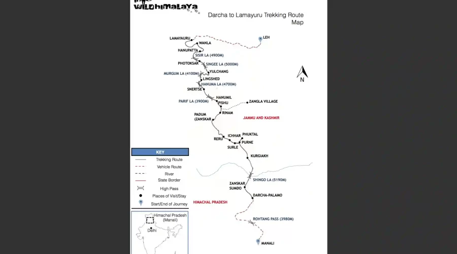
0

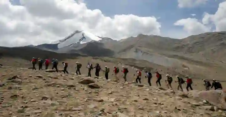
Embark on this sustained journey across the vast Changthang plateau, beginning from Rumtse and concluding in Shang before returning to Leh and Delhi. At a maximum altitude of 5,197 m / 17,050 ft, this trek immerses you in the unique culture of the Changpa nomads, high-altitude salt lakes like Tsokar, and remote hamlets nestled along the Manali–Leh highway. You will cross several high passes and eventually enter the breathtaking Markha Valley, a region famed for its rare beauty and dramatic landscapes.
HIGHLIGHTS:
⭐ Best season: June – October
⭐ Traverse the iconic Markha Valley
⭐ Perfect for photographers and painters with stunning alpine landscapes
⭐ Visit historic monasteries: Thiksey, Shey, Hemis
⭐ Trek over multiple high-altitude passes
⭐ Experience charming remote Changthang villages


🗻 Max Altitude: 216 m / 709 ft
🚌 Travel Distance: ~15–20 km / 9–12 miles
Guests will be received at the airport and transferred to your hotel. Settle in and prepare for the high-altitude adventure ahead with an overnight stay in Delhi.
🗻 Max Altitude: 3,500 m / 11,482 ft
📈 Altitude Gain: +3,284 m / 10,773 ft
✈️ Flight Time: ~1.5 hours
Fly from Delhi to Leh, the capital of Ladakh. After airport pickup, transfer to your hotel for acclimatization. In the afternoon, visit a local monastery, the peaceful Shanti Stupa, and explore the Old Fort of Leh. Overnight stay in Leh.
🗻 Max Altitude: 4,040 m / 13,254 ft
📈 Altitude Gain: +540 m / 1,772 ft
🚌 Travel Distance: 75 km / 47 miles
Depart early for Rumtse, journeying along the scenic highway with stops at Shey, Thiksey, and Hemis monasteries. These spiritual landmarks provide a deep cultural introduction to Ladakh. Camp overnight in the windswept plains of Rumtse.
🗻 Max Altitude: 4,050 m / 13,287 ft
📈 Altitude Gain: +10 m / 33 ft
⏱️ Trekking Time: 5 hours
🥾 Trekking Distance: ~9 km / 5.6 miles
Begin your first day on foot with a gentle ascent from Rumtse to Kyamar. The trail offers open views of the Changthang plateau and ends at a serene campsite near a spring. Overnight stay in tents.
🗻 Max Altitude: 4,200 m / 13,779 ft
📈 Altitude Gain: +150 m / 492 ft
⏱️ Trekking Time: 5–7 hours
🥾 Trekking Distance: ~12 km / 7.5 miles
Today’s trek crosses two scenic passes. Begin with a climb to Kumur La (4,900 m / 16,076 ft), offering sweeping views of the Changthang Range, then descend to a river crossing. Ascend again to Mandachand La, followed by a gentle descent to the pastureland campsite of Tisaling. Overnight stay in tents.
🗻 Max Altitude: 4,627 m / 15,180 ft
📈 Altitude Gain: +427 m / 1,401 ft
⏱️ Trekking Time: 6–7 hours
🥾 Trekking Distance: ~14 km / 8.7 miles
Begin with a steady 2-hour climb to Shibuk La (4,980 m / 16,338 ft), enjoying panoramic Himalayan vistas. Descend through marmot-inhabited meadows to Shibuk, then continue along an expansive flat valley to Tukje, the nomadic headquarters. Explore its Gompa, village life, and take in a serene sunset over the lake. Overnight in tents.
🗻 Max Altitude: 4,580 m / 15,026 ft
📉 Altitude Loss: −47 m / 154 ft
⏱️ Trekking Time: 5.5 hours
🥾 Trekking Distance: ~10 km / 6.2 miles
Trek begins along a dusty path for 1.5 hours before briefly joining the Manali–Leh highway. After a short roadside segment, a 2-hour ascent leads into the Kharanak Rupshu valley, marked by remote beauty. Camp overnight beside a natural spring.
🗻 Max Altitude: 4,550 m / 14,927 ft
📉 Altitude Loss: −30 m / 99 ft
⏱️ Trekking Time: 5 hours
🥾 Trekking Distance: ~9 km / 5.6 miles
Follow an easy trail toward Kharanak Village, where nomadic life thrives. The route then diverts gently to Lungmotche, near the base of Yarla Pass. Camp overnight amidst vast, open highland scenery.
🗻 Max Altitude: 4,200 m / 13,779 ft
📉 Altitude Loss: −350 m / 1,148 ft
⏱️ Trekking Time: 8 hours
🥾 Trekking Distance: ~16 km / 9.9 miles
Cross Yar La, a high-altitude pass where you may spot Kyang (wild Tibetan donkeys) roaming freely. Descend into the remote village of Datt, known for its ancient monastery. Settle in for the night at a scenic riverside campsite.
🗻 Max Altitude: 4,600 m / 15,091 ft
📈 Altitude Gain: +400 m / 1,312 ft
⏱️ Trekking Time: 5 hours
🥾 Trekking Distance: ~11 km / 6.8 miles
Trek through a picturesque gorge, crossing crystal-clear streams. Look out for the ruins of an old castle perched beside the trail. The day ends at Sora, a tranquil village embraced by mountains and barley fields. Overnight camp in this peaceful setting.
🗻 Max Altitude: 4,500 m / 14,763 ft
📉 Altitude Loss: −100 m / 328 ft
⏱️ Trekking Time: 5.5 hours
🥾 Trekking Distance: ~10 km / 6.2 miles
Begin the day with a steady climb to Zalung Karpo La (5,197 m / 17,050 ft), the highest pass of the trek, offering spectacular views of the surrounding ranges. Descend on a rocky, dusty trail to reach Langthang Chhu, where you’ll camp near the glacial stream.
🗻 Max Altitude: 4,900 m / 16,076 ft
📈 Altitude Gain: +400 m / 1,312 ft
⏱️ Trekking Time: 5.5 hours
🥾 Trekking Distance: ~11 km / 6.8 miles
The day begins with a gradual ascent, followed by a steep 4-hour climb to a high ridge. The trail eases out onto the broad Nimaling Plateau, set beneath Kang Yatse (6,200 m / 20,314 ft). Spot yak, sheep, and goat herds grazing freely in this dramatic landscape. Overnight camp under starry skies.
🗻 Max Altitude: 3,640 m / 11,942 ft
📉 Altitude Loss: −1,260 m / 4,134 ft
⏱️ Trekking Time: 8 hours
🥾 Trekking Distance: ~15 km / 9.3 miles
Begin with a zigzag 2-hour ascent to the panoramic Kongmaru La (5,150 m / 16,896 ft). From the top, descend steeply through Chuskirmo and a scenic riverbed trail. The path leads through colorful rocky landscapes to the serene village of Shang, where you’ll explore a small Gompa and monastery. Overnight camp at this tranquil spot.
🗻 Max Altitude: 3,400 m / 11,154 ft
📉 Altitude Loss: −240 m / 788 ft
🚗 Travel Distance: 60 km / 37 miles
Begin your return to Leh with a scenic drive from Shang, passing through Hemis Monastery, perched near the Indus River. Along the way, also explore the Thiksey Monastery and historic Shey Palace. Arrive in Leh by afternoon and settle into your hotel for a well-earned rest.
🗻 Max Altitude: 216 m / 709 ft (Delhi)
📉 Altitude Loss: −3,184 m / 10,445 ft
You’ll be transferred to the Leh airport for your domestic flight to Delhi. Upon arrival, a representative will escort you to your hotel. The afternoon is free for personal exploration, relaxation, or last-minute shopping. Overnight stay in Delhi.
🗻 Max Altitude: 216 m / 709 ft
Spend your final day in Delhi exploring either Old or New Delhi at your leisure. Discover bustling markets, historic landmarks, or relax at a café. Later in the evening, you’ll be transferred to Indira Gandhi International Airport for your onward journey.
Arrival From Indira Gandhi International Airport (New Delhi)
Departure From Indira Gandhi International Airport (New Delhi)
Domestic flight and train journey along with all internal road transfers
Certified Mountain Guide with mountaineering and first aid training
Support Helpers to assist with kitchen and camp duties
Pack Horses for carrying gear and supplies
All Trekking Equipment: tents, sleeping bags, mats, kitchen and toilet tents
All Meals: breakfast, lunch, tea/snacks, soup, and dinner
Accommodation: twin-sharing tents
Transportation: all local transfers as per itinerary
Emergency Kit: first aid and oxygen canister
Package price excludes anything not mentioned under “Inclusions,” including flights, insurance, tips, rentals, and emergency costs.
Rental gear available at: Into Wild Himalaya Shop
Trekking boots (well broken-in, ankle support)
Camp sandals or lightweight shoes (for evenings)
Backpack (40–50L with rain cover)
Small daypack or summit pack (20–30L)
Sleeping bag (rated -10°C to -20°C)
Sleeping mat (foam or inflatable, optional)
Trekking poles (adjustable)
Base layers (1–2 sets, moisture-wicking top & bottom)
Fleece or light down jacket
Waterproof jacket (with hood, breathable)
Waterproof pants (with side zips)
Trekking pants (quick-dry)
Thermal tights
T-shirts (synthetic or merino wool)
Thin liner gloves
Insulated gloves
Woollen cap or balaclava
Neck gaiter or Buff
Sunglasses (UV protected)
Sun cap or wide-brimmed hat
Wool or synthetic socks (3–4 pairs)
Headlamp (with spare batteries)
Water bottles (2L total, insulated preferred)
Thermos flask (for high-altitude regions)
Water purification tablets (optional)
Personal first aid kit (blister care, pain relief, altitude meds)
Sunscreen (SPF 50+)
Lip balm (SPF 30+)
Toiletries (eco-friendly, biodegradable)
Wet wipes and hand sanitizer
Quick-dry towel
Snacks (energy bars, trail mix, nuts, dry fruits)
Electrolyte tablets or ORS
Camera or GoPro (optional)
Passport, permits, and some cash (in waterproof pouch)
Safety is our top priority. Our guides are trained First Aid Responders and prepared for high-altitude situations. Every trek, expedition, and motorbike tour includes a comprehensive first aid kit tailored for remote and high-altitude environments.
Core Medical Supplies
Wound Care: Bandages, sterile gauze, antiseptic wipes, antibiotic ointment
Blisters & Burns: Moleskin, burn gel, petroleum jelly
Fractures & Sprains: SAM splint, triangular bandage, compression wraps
Medications: Painkillers, antihistamines, anti-diarrheal, ORS, antacids, Diamox
Tools: Tweezers, scissors, gloves, CPR face shield, thermometer, pulse oximeter, whistle, mirror
Additional (for Remote/Extended Treks)
Tourniquet, emergency bandages, quick-clot gauze, sterile eye wash, foil blanket, water purification tablets
Optional Add-ons (As Needed)
Personal meds (inhalers, insulin, EpiPen)
Snake bite kit (in high-risk zones)
Tick remover (for forested routes)
High-Altitude Protocol
Above 4500 meters: A portable hypobaric chamber is always carried for emergency altitude management.
More than 30 days before your trip: 90% refund
15–30 days before: 50% refund
7–14 days before: 25% refund
Less than 7 days or no-show: No refund
Custom/private trips: Booking advance is non-refundable. Last-minute changes are subject to availability and costs.
For more details on our cancellation policy, please refer to the following link:
https://iwhexpeditions.com/cancellation_policy/